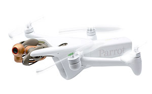
Parrot ANAFI Ai
Parrot ANAFI Ai is compact professional drone, built for work, setting a new communications standard, open to developers, with a full open source app, autonomous 1 click photogrammetry and new levels of cybersecurity. See video here
4G connectivity
As the Parrot ANAFI Ai drone connects to the 4G network there will no longer be transmission limitations
 and therefore enables precise control at any distance. And for Beyond Visual Line of Sight operations, it stays connected even behind obstacles.
- Connected without range limit
- Flies Beyond Visual Line Of Sight
- Worldwide compatibility
Cybersecurity by design
The drone embeds a Secure Element and in its Skycontroller 4. This means that the 4G link between the
 drone and the user’s phone is encrypted, protecting both the integrity of the software and the privacy of data transferred.
- No Data shared by default
- Strong authentication for 4G
- FIPS140-2 compliant and CC EAL5+ certified Secure Elements
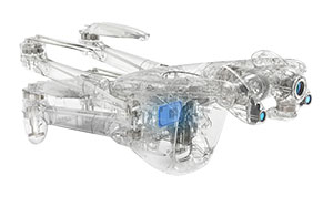
A unique robotic platform.
Parrot's large partner ecosystem delivers a wealth of specialized applications and services for a variety of
 professional uses. Parrot is the first in the industry to make its piloting application open-source. Parrot offers developers a Software Development Kit (SDK) to execute custom code in the Parrot ANAFI Ai drone during the flight. The SDK gives access to all flight sensors, including obstacle avoidance sensors, occupancy grid and internet access.
- Software Developer Kit with onboard coding capabilities
- Full open-source App
- The largest Partner Ecosystem for drones
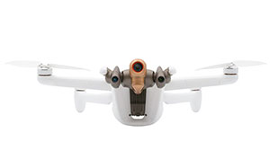
Autonomous flight
Parrot ANAFI Ai’s obstacle-avoidance (OA) system detects obstacles in all directions, using stereo cameras to sense objects and automatically avoid them and automatically determines the best trajectory to pursue its mission.
Embedded Artificial Intelligence allows for photogrammetry-specific flight plans to be performed
 automatically, optimizing productivity, and saving time. Professionals can generate optimized missions based on the land registry of the building selected in just one click.
Parrot ANAFI Ai’s Quad Bayer 48 MP sensor delivers survey-grade accurate 2D and 3D models. It offers the same precision as drones with a 1" 20MP sensor, while flying 1.5 times higher. A GSD of 0.46 cm/px is obtained at an altitude of 30 m. Pictures can be captured at 1fps, 2x faster than any other drone in the market.
- Shoots 48 MP at 1 fps
- Survey grade accuracy: 0.46 cm/px GSD at 30 m
- Embedded PIX4D flight planning
- 4G transfer to PIX4Dcloud
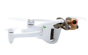
48 MP Camera
- 4K 60 fps: Smooth video
- HDR10: Realistic colors
- 14 EV: Dynamic range
- 6x zoom: 1 cm details at 75 m
Pre-order now